Everything before helps you understand. Before take-off you need numbers. A useful briefing always follows the same path: first the general weather situation, then the route, and finally the airfield – and at the end the question of what will make you abandon the flight.
1. The general weather situation
The surface chart and the upper-air chart answer the basic question: where are the highs and lows, how tight are the isobars, where are fronts drawn and where are they heading? Together with the written weather overview, this gives the framework. Everything after that is detail.
2. The route: GAFOR
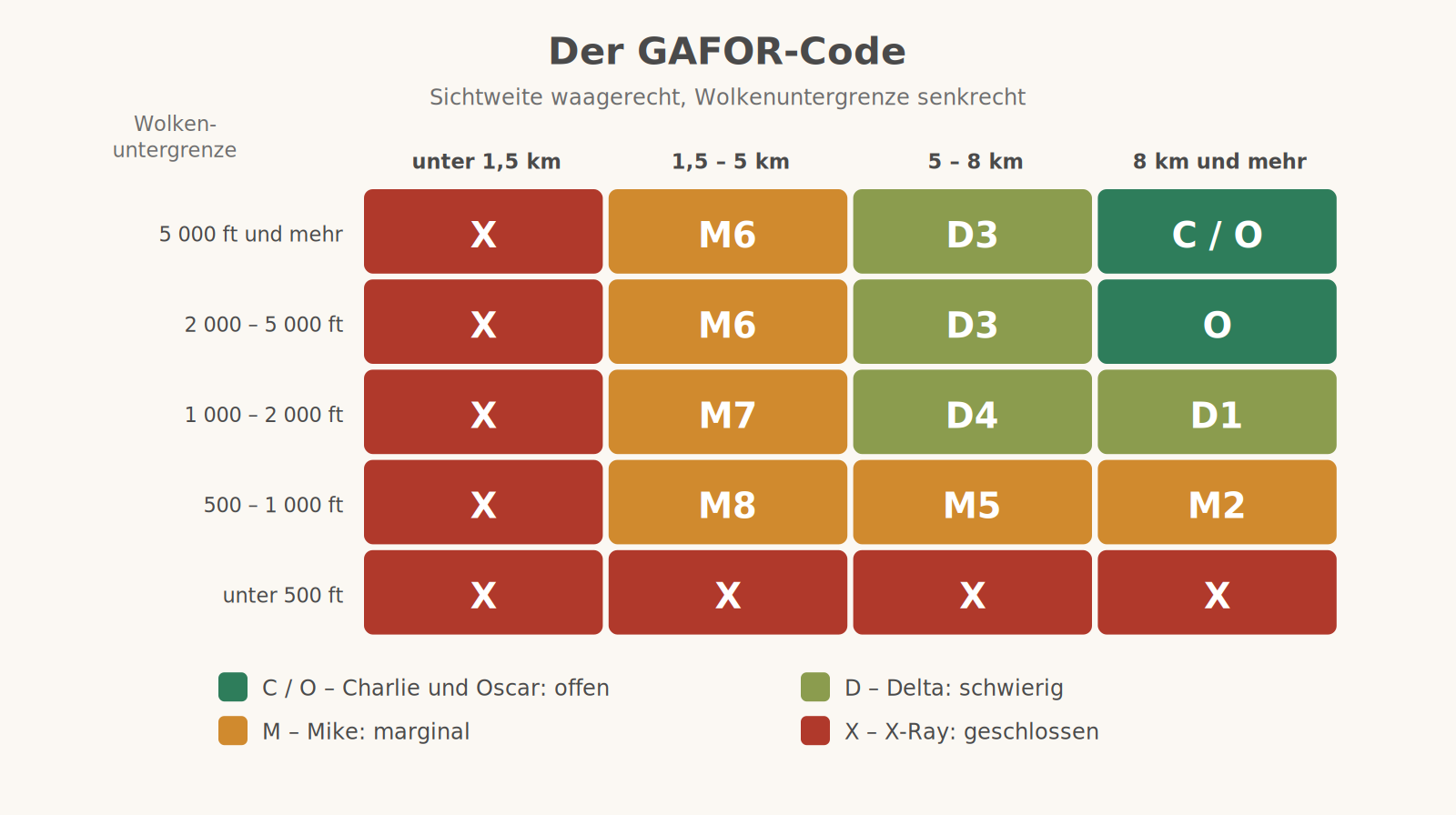
The GAFOR (General Aviation Forecast) is the route forecast for VFR flying. For this purpose Germany is divided into some eighty route sections; for each section there is a two-character code made up of visibility and cloud base.
- C – Charlie, clear: visibility 10 km or more, base 5,000 ft or more
- O – Oscar, open: visibility 8 km or more, base 2,000 ft or more
- D – Delta, difficult: visibility 5 km or more, base 1,000 ft or more
- M – Mike, marginal: visibility 1.5 km or more, base 500 ft or more
- X – X-Ray, closed: below that
The GAFOR is issued five times a day and is valid for six hours each time, divided into three two-hour time blocks. Two things are regularly misunderstood: the heights refer to a reference altitude defined for each section – not to the airfield and not to the valley floor. And the code describes the weather along the route, not at the departure or destination airfield. An O tells you nothing about whether your home airfield is clear.
3. The airfield: METAR and TAF
The METAR is a weather report, not a forecast: it describes what is currently being measured and is issued every half hour or every hour. The TAF is the aerodrome forecast for the coming hours.
METAR EDMA 011020Z 27008KT 9999 FEW035 SCT090 18/09 Q1019 NOSIG
EDMA | Airfield identifier |
011020Z | 1st of the month, 10:20 UTC |
27008KT | Wind from 270 degrees at 8 knots |
9999 | Visibility 10 km or more |
FEW035 | 1 to 2 oktas of cloud at 3,500 ft |
SCT090 | 3 to 4 oktas at 9,000 ft |
18/09 | Temperature 18 degrees, dew point 9 degrees – spread 9, so a cloud base of about 1,100 m |
Q1019 | QNH 1019 hPa |
NOSIG | no significant change expected |
The cloud cover categories are FEW (1–2 oktas), SCT (3–4), BKN (5–7) and OVC (8 oktas). CAVOK stands for visibility 10 km or more, no cloud below 5,000 ft and no significant weather.
TAF EDMA 010500Z 0106/0118 25010KT 9999 SCT030 TEMPO 0112/0116 30015G25KT 6000 SHRA BKN020CB
Read as: issued on the 1st at 05:00 UTC, valid from 06:00 to 18:00 UTC on the 1st. Base conditions wind 250 degrees at 10 knots, visibility over 10 km, scattered cloud at 3,000 ft. Temporarily between 12:00 and 16:00 UTC: wind 300 degrees at 15 knots gusting 25, visibility 6 km, rain showers, broken cloud at 2,000 ft with cumulonimbus. The TEMPO block is the real information – that is where you find what can tip the flight over.
Where to get it
The German Weather Service (DWD) is responsible. Some of the aviation weather products – the air sports reports, the aviation weather forecasts for the North, Centre, West and South regions and the GAFOR overview – are freely available on dwd.de. The complete range with all charts, radar and satellite images is in the paid portal flugwetter.de; there is also the DWD FlugWetter app. For Austria, Austro Control provides the corresponding products, for Switzerland Skybriefing. The links to the AIS portals are one level up under Flight Planning.
What this means for a flying day
- Always from big to small. If you start with the METAR of your destination, you will not see the trough that passes through at 3 pm.
- The point at which you turn back belongs before take-off. Not "I'll see how it goes", but: at what visibility, what cloud base and what time do I turn around?
- An alternate with better weather is part of the plan – and one that is still open at your arrival time.
- Temperature and dew point from the METAR take two seconds and say more about the evening than any forecast.
- The GAFOR is not aerodrome weather. For the airfield, the METAR, the TAF and a look outside apply.
This page summarises how we handle the briefing. The official aviation weather briefing is always binding; codes and issue times may change.