Wind is nothing but air trying to even out a pressure difference. How strongly it does so is shown by the isobars on the weather chart – and the reason it does not flow straight but around the pressure systems is the rotation of the Earth.
The pressure gradient: the cause
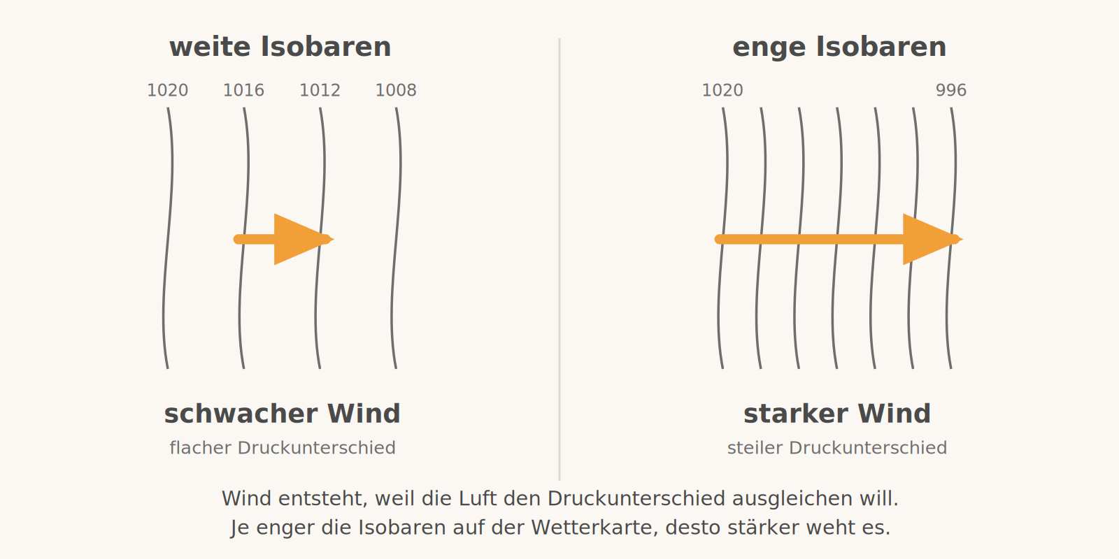
Between an area of high pressure and one of low pressure, a force arises that pushes the air from the high towards the low – the pressure gradient force. The greater the pressure difference over a given distance, the stronger this force and the stronger the wind.
You can see this immediately on the weather chart: isobars connect places of equal air pressure, usually at intervals of 5 hPa. If they are far apart, the pressure is evenly spread and the wind is light. If they are crowded together, the transition is steep and it gets windy.
The Coriolis force: the deflection
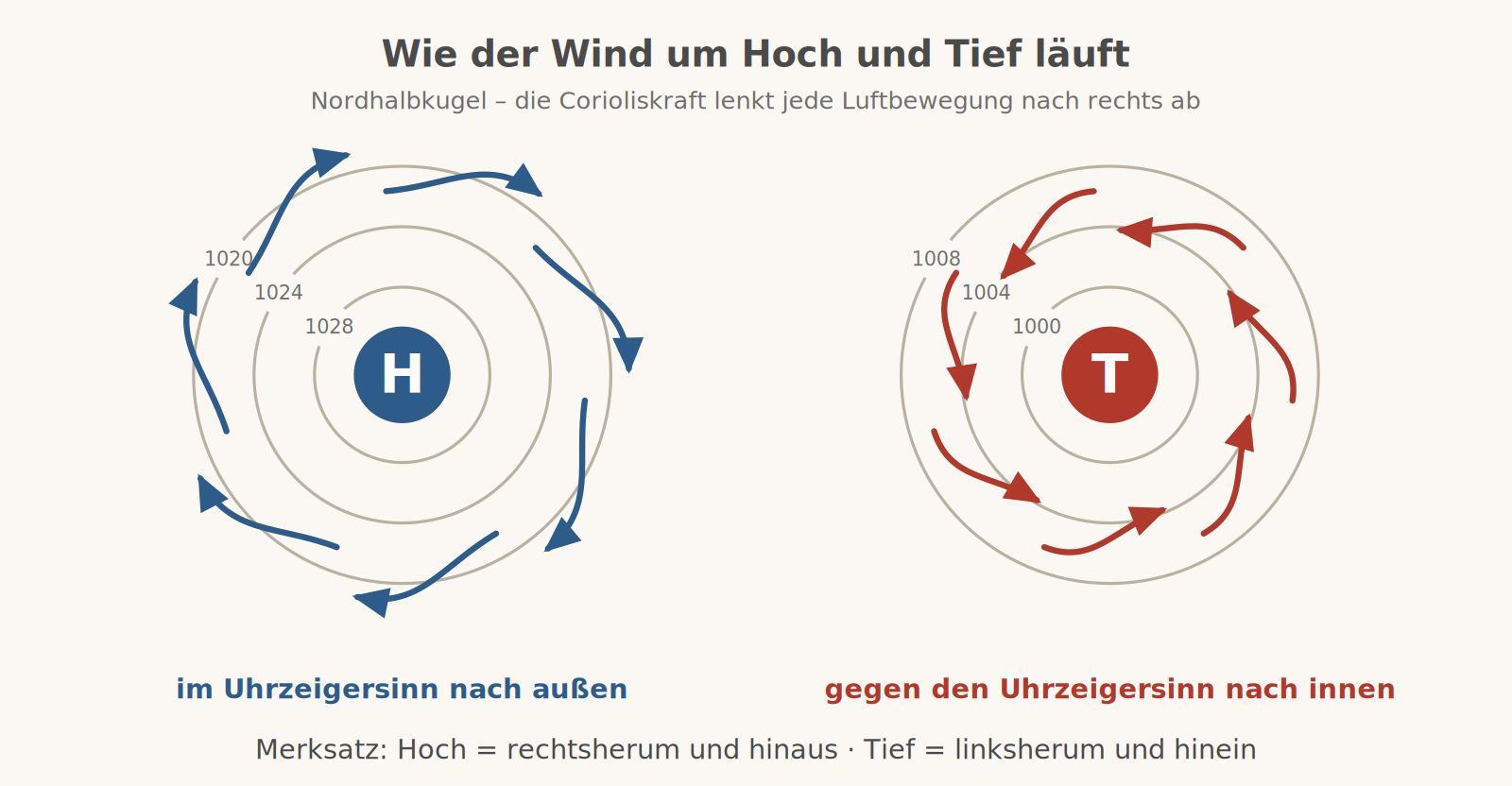
The Earth rotates away beneath the moving air. To an observer on the ground it looks as if every motion in the northern hemisphere is deflected to the right. This apparent force is named after its discoverer, the Coriolis force; it increases with wind speed and vanishes at the equator.
In the free atmosphere, the pressure gradient force and the Coriolis force balance each other. The wind then does not blow from the high to the low but parallel to the isobars – this is called the geostrophic wind. This gives the direction of rotation: clockwise around a high, anticlockwise around a low.
Friction: why everything is different down low
Near the ground, terrain, forest and buildings slow the flow. The wind becomes slower, so the Coriolis force becomes smaller too, and the air crosses the isobars at an angle – about 30° over land, 10° to 20° over water. That is exactly why a low fills up over time: the inflowing air has to leave again at the top.
With increasing height the influence of friction decreases. The wind becomes stronger and veers to the right in the northern hemisphere – an effect that is clearly noticeable even between circuit height and cruising altitude.
What this means for a flying day
- First the isobars, then the wind forecast. Tight isobars over Bavaria mean: today it will be unpleasant at the ground too, whatever the point forecast says.
- There is more wind aloft than below – and from a different direction. Anyone who takes the surface wind for the circuit regularly underestimates the drift on the downwind leg.
- Gusts are upper wind breaking through to the ground. With unstable layering, faster air from above mixes down; the peaks can then easily reach twice the mean wind.
- Behind obstacles lies the rotor. Forest edge, hangar, ridge: the disturbed zone extends about ten to twenty times the obstacle height downwind.
- In the Alpine foothills, everything is overlaid by the valley wind. On calm, sunny days the up-valley wind sets in during the morning and reverses in the evening – regardless of the large-scale situation.
Remember
Tight isobars = strong wind. High: clockwise and outwards, low: anticlockwise and inwards.