Thermals are the reason why a flying day is smooth at ten o'clock and bumpy at two. They arise from nothing more than sun, ground and a temperature difference – and they determine how high the clouds are, how gusty final approach will be and when the day is over.
The engine
The sun does not heat the air but the ground. The ground passes the heat on to the layer of air above it. Because not every surface warms up equally fast, patches form: a harvested field, a quarry, a village heat up much faster than forest or water. Above the warmest patch, at some point a bubble detaches from the ground and rises – the updraught glider pilots call a thermal.
As it rises, the bubble cools by about 1 °C per 100 metres. When it reaches the point at which its moisture condenses, the cloud forms. That is why there is a cumulus above every working thermal – and why on dry days there are thermals without any clouds at all, so-called blue thermals.
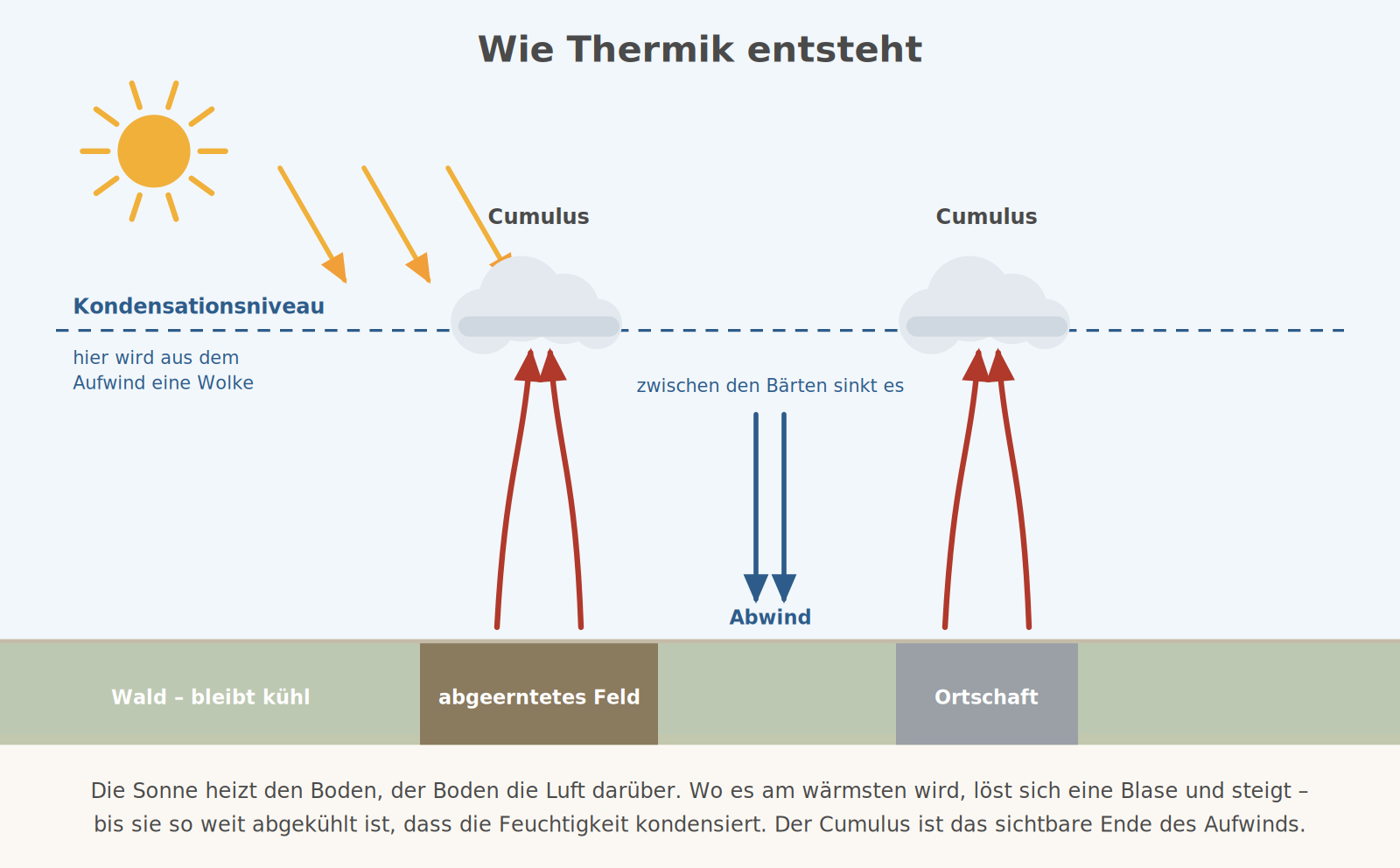
What goes up must come down somewhere else. Between the thermals the air sinks over wide areas. That explains why on a good thermal day it feels as if you are constantly flying downhill: the sink zones are much wider than the columns of lift.
Why sometimes nothing works
Whether the bubble keeps rising does not depend on the bubble itself but on its surroundings. If the surrounding air cools faster with height than the bubble, the bubble always remains the warmer one and keeps rising – the layering is unstable. If the surroundings cool more slowly, the bubble soon becomes the colder one and sinks back – the layering is stable.
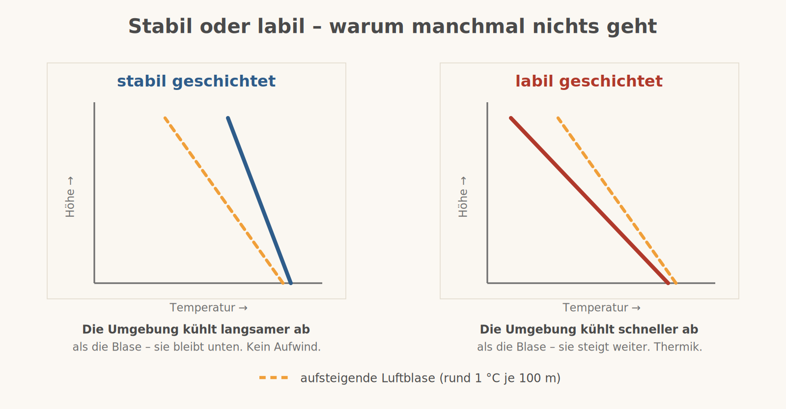
An inversion – a layer in which the temperature actually increases with height – acts like a lid. Haze and moisture collect beneath it, and the thermals stop there. That is exactly what happens under a strong high.
The daily cycle
In the early morning the air near the ground is at its coldest and the layering is stable – nothing happens. With the sun, the mixed layer grows from the bottom up; around midday the thermals set in and reach their maximum in the early afternoon. In the late afternoon they weaken, and when the thermals stop the air becomes smooth almost instantly. Over the Alps the whole cycle runs about an hour earlier than in the lowlands, but considerably stronger.
What this means for a flying day
- The cloud base can be estimated. The spread in degrees Celsius times 125 gives roughly the height of the cumulus base above ground in metres. With 8 °C between temperature and dew point, that is about 1,000 metres.
- The smooth flight is in the morning and the evening. If you take passengers who are new to flying, do not plan for 2 pm.
- Expect shear on final. A thermal right next to the runway can make the airspeed fluctuate by ten knots; an approach with a little extra speed is the better choice on such days.
- Blue thermals are invisible but real. No clouds does not mean calm air.
- Overdevelopment announces itself. When the base rises during the day and the clouds shoot up at the same time, the nice thermal day turns into a thunderstorm day.
- The thermal is not vertical. In wind, the updraught drifts with height – the cloud does not sit above its trigger.
Remember
Unstable means thermals, turbulence and good visibility. Stable means smooth air, haze and a lid.